Align Images

A-Cad has a function with raster design to align an image (affine transformation) with points.
first you align the image as goos as possible with varia and rotation. After that you can pick a point on the image, and on the drawing. At least 3 point. More is better and raster design align the image to this points.
Is there an command in Bricscad that can do this?
Comments
-
MATCHPERSPECTIVE?0
-
Thats not it:
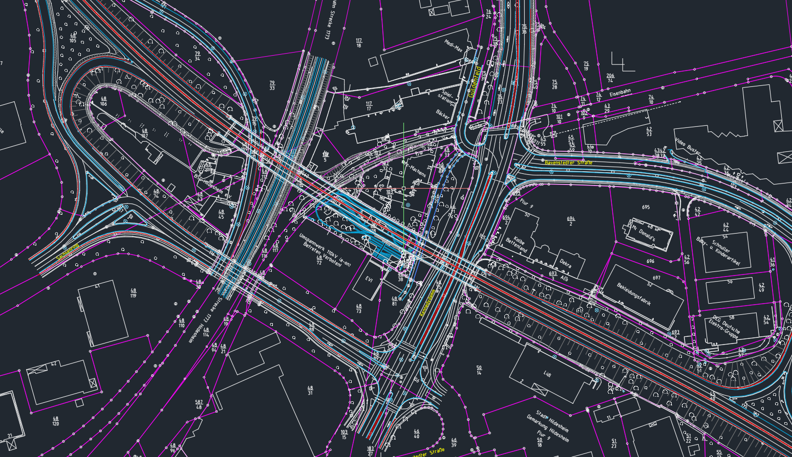
A-Cad Raster design:First you have a drawing:
Second you attach an image, for example of an old Projekt in this area:
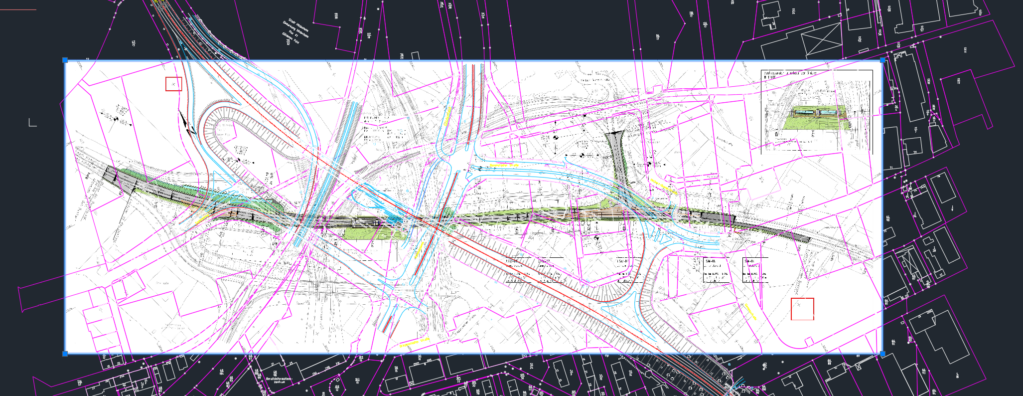
The image is in the project area but does not align with the drawing
third you use A-Cad Raster design to match points on the image an the drawing:
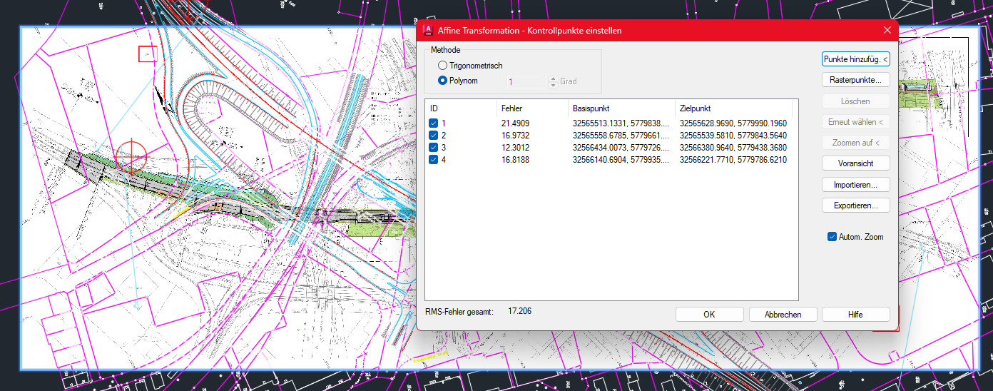
Click ok ans the image is set
 0
0 -
Ah yes - handy.
What a nightmare image!
0 -
Yeah the Image is quick and dirty for the Screenshots. And now the Question: does have BricsCad an feature like this?
My Company wants to move from A-Cad to B-cad. I tested B-Cad for 3 month now. and this is one nice feature i am going to miss0 -
I think ALIGN.
Which seems quite feature rich for an align tool, since early Bricscad Versions.
There was an old Video somewhere on their Youtube channel where you could orient/rotate/scale a Selection in one go.
Hope it works for images too (?)0 -
I use ALIGN all the time - but only two points (or three if using it in 3D)
0 -
Agree Acad or Bricscad use Align have done so for years. If you have true reference points like benchmarks use those zooming in on image to pick points.
Is the image in another dwg ? May be able to copy Ctrl+c then paste to original co-ordinates. Or use image co-ords and scale .
0 -
@ALANH no. The jpg files are 30-60 Years old scanned paper drawing or aerial views without coordinates. So we get digital property boundaried and we have to align aerial views. the Only points available are buildingcorners seen on the image and the bounderies.
@tom Foster: i testet align (German: Ausrichten) its a start but it doesn't scale the image in x and y independently. The Image ratio hight to length does not change,0 -
I see - you need independent x, y scaling. AFAIK the only way to do that in BC is to make a Block out of it, which can then be scaled independently on insertion.
0 -
So the answer for now ist no. BricsCad can't do this for now nativ. I have to fiddle. Aligne will help but not perfect.
Thanks for the answers.0 -
If you know the unequal scaling ratio, I would re-scale the image in an image editor,
reimport and align.0 -
@zoomer you never know the scalling ratio. It depends on the quality of the image.
Raster design is not jut scaling x and y. Its Roation, scaling, aligning and when necassery the image is deformed completly. It's a nice and handy tool.
when my company moves to Bricscad we have to find a work arround or an (paid) add-on.
0 -
I meant first using Align in Bricscad to estimate the Image status,
AFAIR Align does Rotate (at least to one Axe), Scale (at least to one Axe) and Align (at least to one special Point) at a time.And I thought that could be best way to examine the status of the Image and read out all necessary uneven Scaling and possible Distortions. For correcting that Image I think it would be best to create a optimized Image Copy in an Image Editor like Photoshop or GIMP, … then going back into Bricscad, to redraw the content based on the imported new image. I think that would offer the best accuracy you can achieve.
0 -
So … what's needed is not just scaling independently in x and y, but localised scale adjustment to correct various existing local distortions? That's definitely one for Photoshop/Gimp etc - surely Acad can't do that? If it's possible to align direction by picking corresponding points in both image and model, then surely that can be created in Photoshop/Gimp at the same time, so the finished de-distorted image is then a drop-in/paste-in to the model?
0 -
Helmert transformation is what you want but no idea if available for an image. It uses points to rubber map say an image.
I used Paint.net a free program and changed the X Y etc values and resaved the image.
0 -
OpenCV can probably do this. If you can code in python, you may be able to build a script
0 -
@tom foster: Acad can't do this. you need raster design for acad.
@alanh: Yes thats it. Stratis from RIB was able to helmert tramsformation Images back in Version 9 (2003)
@Its_Alive : i will ask the IT department in my Company.
Thanks. and yes there are paid add ons for Bricscad. But if i need add ons for some features then the price benefit from Bcad is getting smaler in comparrision to acad. The boss will ask: why switch to bcad when we need extra software und can't safe money
0 -
You could try looking in the BricCAD application store for rubbersheeting apps
e.g
https://boa.bricsys.com/applications/a/?vpmap-series-a1198-al2126
https://boa.bricsys.com/applications/a/?adjust-a876-al1532
Or Spatial Manager.
Or use QGIS if the CAD drawing is georeferenced. If the CAD file is georeferenced then I would prefer proper GIS software to rubbersheet and georeference an image.
I guess you are using AutoCAD Map or AutoCAD Civil at the moment? BricsCAD Civil is still in development compared to those two, but in combination with free QGIS you can get close for such functionality. Or if you are also using ArcGIS or other dedicated GIS software. When I used AutoCAD Map and Civil (the latter being worse for proper GIS than Map) I still preferred using proper GIS software for such things.
0