Höhenkoten, altitude coefficient, grade

I really tried to find a solution here and online before Posting
does BCAD have a command to automate Höhenkoten (ger) altitude coefficient. I hope it is the Englich word for this:
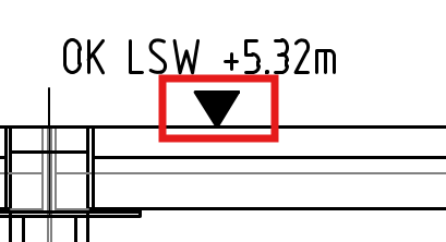
OK LSW → Oberkante Lärmschutzwand (top edge noise barrier)
for 2D drawings. for Example i have an section through a Building oder tunnel. I do not have any 3D model. But i have a known horizon with altitude x. so i hope that a can define this altitude and BCAD can write the hight on the altitude coefficient automaticly. There are paid solutions, but before my company buys extra software, i want to be sure that BCAD can't do this.
Comments
-
Look into pick reference point this sets your 0.0, Y value, when you pick a point you can work out the +- difference, then just have a block with one attribute, the attribute value will be inserted along with the triangle symbol.
The one issue is when using is to do a check is this correct zero level point, you could do a (setq pt2 (getpoint zeropt "\n Pick rl point ")) this will draw a rubber band line as you pick a point for RL. So then do use yes/no.
Can you post a dwg with the block as suggested, use wblock. It will be a lisp.
0 -
This is just the Block, But i don't unserstand what you mean with this: (setq pt2 (getpoint zeropt "\n Pick rl point "))
0 -
When you pick a point you have to somehow compare that point to a Zero rl point. So you set the point and can then do multiple points.
Code
; Simple datum based on 2 pointsby AlanH July 2025
(defun c:datum ( / rlpt pt y)
(setvar 'attreq 1)
(setq rlpt (getpoint "\npick point for zero RL "))(while (setq pt (getpoint rlpt "\nPick datum point Enter to stop "))
(setq y (rtos (- (cadr pt)(cadr rlpt)) 2 2))
(command "-insert" "RL" pt 1 1 0 (strcat "Rl " y))
)(princ)
)Please look at the dwg attached it has block "RL" you may want to make again just made to test code.
0 -
i am a civil engineer but i am to dumb for coding.
i copied your code in a textfile. saved it a Datum.lsp and when i want to use it. Bricscad sais command not recognised "insert"
0 -
To start again from the beginning:
No, BricsCAD has no turnkey support for architectural dimensioning according to DACH standards.
For your ordinate dimensions, there are a couple of possible approaches to tackle this problem:
1.) Use blocks with an attribute, insert them and put a field into the attributes that either reflects the y-coordinate of the blocks insertion point, or its distance to another insertion that serves as an origin marker (this is shown in levelblocks.mp4).
2.) Use a combination of blocks and ordinate dimensions (I gave up on this).
3.) Use mleaders with fields (I did not try this).
4.) Use base dimensions with special formatting (this is shown in leveldimensions.mp4).
Both shown methods have their pros and cons:
Using attributed blocks does not need a reactor and is overall simpler, but needs a drawing regeneration for the fields to update, and the blocks are not attached to the annotated geometry (you would have to create constraints for that).
Using base dimensions seems the most natural solution to me, but is more demanding - the drawing has to be set up correctly, and the script that creates the dimensions is quite complex. As you will notice in the mp4, the placement of the dimension text is often initially bad and needs manual correction.
If one of these approaches looks promising for you needs, you might try the attached scripts. You would have to include the folder "AEC_Annotate" into BricsCAD's search path via the settings command, and load the contained menu file (aec_annotate.cui or .mnu) via the menuload command. But be warned that you are likely to stumble over bugs - these scripts have "works for me" status, but are not really ready for release.
(If you need further explanations in German, send me a PM)
And concerning your last post - I guess you use a localized version of BricsCAD: You need to prefix English command names with an underscore in order to get them recognized, so "insert" should be "_insert".
0 -
What I forgot to mention:
have a look at http://www.archtools.de/D-ArchDIM/archdim.html
This has been a commercial application for decades, but is now given away for free. It should be much more mature than my stuff, but I can't say for sure, because I have been happy enough with my DIY-solution to not look into it.
0 -
Sorry a typo by me need "-insert" so it does not Call the dcl.
(command "-insert" "RL" pt 1 1 0 (strcat "Rl " y))
0 -
Hello. I got time to test your answers
@knut I testet your AEC Tool. It Intervenes with our standard .dwt file. That file has all kinds of scaling. 1:10, 1:25; 1:100; ….. And your tool delets them. And the Tool is english. Not all my coworkers will be able to work with that.But i got the script working from Alanh. and it is _insert not -insert. I will test all three thing: Alanhs script, the aec tool and the Archtools.
My company is going to switch to BricsCad in October. Until then the test License will be expired.
So thanks for the Help.0
