LAZ support

Hi, i noticed that LAZ files many cases doesn't work that well.
- Loaded but unable to get a visiual?
- Unloaded but still visible?
Anyone having the same issues.
Many my files are to big? 100-200 mB should be no problem
Comments
-
Hi Hans,
Could it be that the LAZ files contain geographic location information? We've recently implemented that, and it will be available as of V22. If so, the scaling XY vs. Z is lon/lat vs. meter in the file, but erroneously interpreted as the same unit in versions < V22.
If not: Could you perhaps provide an example file, e.g. via a support request, for us to reproduce the undesired behavior? Please also indicate which version of BricsCAD, and the various steps which led to the undesired behavior.
Also: Did you try using the "looking from" widget (the chair in the upper right corner) to get the camera to display everything in the drawing? It might be that for a LAZ which is already preprocessed before, the view frustum is not automatically set.
Best regards,
Sebastian0 -
@SebW said:
Could it be that the LAZ files contain geographic location information?This needs to be considered for every mapping file imported (or exported). For example LAZ files usually have coordinate systems in the header in records similar to GeoTIFF (the surface grid, not the image). The current drawing may happen to be on that coordinate system but many times will not be and the LAZ points will need to be projected to the target (drawing) system. For example right now one of our users is receiving LAZ content from the US Govt in UTM83-16 (metric) and their drawing is in TN83F (feet). UTM to State Plane is a common occurrence.
Also, don't be surprised by the massiveness that can be thrown at you from Lidar. For example a previous project in Texas involved (4) LAZ files covering roughly 10,500 acres. Those (4) files were 5.2gb (even with LAZ compression) containing almost 450 million points, 284m of which were class (2) ground.
So think BIG, because you can bet somebody down the road is going to throw BIG at you.
0 -
Some of the LAZ files i use
https://geotiles.nl/AHN4_T/32BZ2_13.LAZ
https://geotiles.nl/AHN4_T/32BZ2_12.LAZI don't think these LAS of LAZ files contain additional information of the location
But before i made wrong conclusions and statements please investigate them.
On the same site you can find some of the details.About thinking BIG
") It is a pity Twinmotion is not able to work with Laserscan data.
It is a pity Twinmotion is not able to work with Laserscan data.
How can one visualize this like in Recap?0 -
Those files contain a VLR Record ID: 2112
"COMPD_CS["Amersfoort / RD New + NAP height",PROJCS["Amersfoort / RD New",GEOGCS["Amersfoort",DATUM["Amersfoort",SPHEROID["Bessel 1841",6377397.155,299.1528128,AUTHORITY["EPSG","7004"]],AUTHORITY["EPSG","6289"]],PRIMEM["Greenwich",0,AUTHORITY["EPSG","8901"]],UNIT["degree",0.0174532925199433,AUTHORITY["EPSG","9122"]],AUTHORITY["EPSG","4289"]],PROJECTION["Oblique_Stereographic"],PARAMETER["latitude_of_origin",52.1561605555556],PARAMETER["central_meridian",5.38763888888889],PARAMETER["scale_factor",0.9999079],PARAMETER["false_easting",155000],PARAMETER["false_northing",463000],UNIT["metre",1,AUTHORITY["EPSG","9001"]],AXIS["Easting",EAST],AXIS["Northing",NORTH],AUTHORITY["EPSG","28992"]],VERT_CS["NAP height",VERT_DATUM["Normaal Amsterdams Peil",2005,AUTHORITY["EPSG","5109"]],UNIT["metre",1,AUTHORITY["EPSG","9001"]],AXIS["Gravity-related height",UP],AUTHORITY["EPSG","5709"]],AUTHORITY["EPSG","7415"]]"
Which at a glance appears to be EPSG:7415. If your current drawing is on a different coordinate it should be projected to that. You see what I mean about BIG as just your "_13" tile has roughly 52 million points.
0 -
EPSG:7415 is the right one for Netherlands 3D (RD/NAP) This one is not in the list in BricsCAD to choose from.
 0
0 -
Bricsys needs to do a lot of work on their coordinate projection system, for both the end users and in the APIs. I don't understand the dialog you show, it looks like they are allowing the user to pick a random location in their drawing and give it a lat/long for that location. If that's the case it looks like they followed the 'desk down the rabbit hole of their GEOLOCATION command, bad voodoo.
It simply DOES NOT work that way, you cannot simply point to a location and give it a lat/long. Established named (and EPSG numbered) coordinate systems have a usable coordinate range (coordinates usually in the hundreds of thousands or millions) and objects must take on the coordinates of that system where they reside. I've seen drawings from people who used the 'desks approach that are in INCH/MM units, have small coordinates and are essentially GeoGarbage since you can't export the content to GE and you can't import properly positioned content either.
0 -
I don't really know all the functions that use GEOLOCATION in bricsCAD. But i do know that for WMS functionsin MAPCONNECT this is needed. And that seems logical because immages have to be aligned. I thought the missing of this EPSG might have to do with not very good functioning of LAZ.
0 -
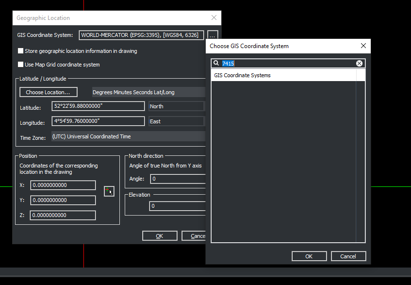
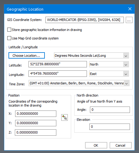
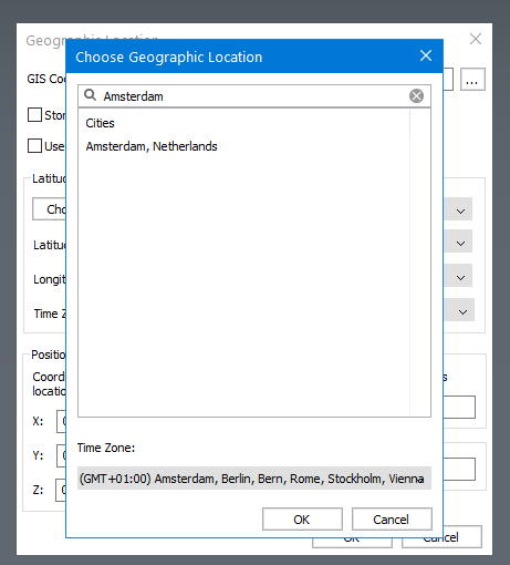
@Hans Lammerts said:
EPSG:7415 is the right one for Netherlands 3D (RD/NAP) This one is not in the list in BricsCAD to choose from.In the geographic location dialog, Latitude/Longitude section click on the "Choose Location..." button and search for Amsterdam and then confirm that choice.
Then click on the dotted button after the GIS Coordinate System line and search for Amersfoort or RD.. and you will see this: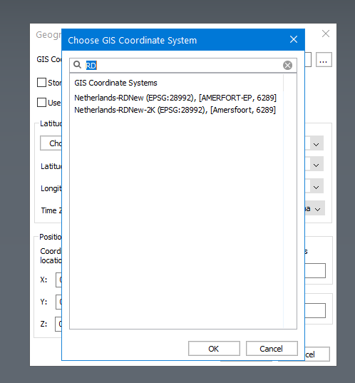
Unfortunately EPSG:7415 is not listed at all, but it should be because the EPSG catalog is free to use so there is so I don't see why it had to be excluded.
Though EPSG:7415 is an Oblique Stereographic Alternative projection. It's a spherical projection you may have seen as maps of the North or South Pole. For your purpose you may want to reproject to one of the two supported RD systems in BricsCAD.
QGIS can do this, or if you don't already have MapWorks (from Dotsoft) should be able to handle this too as it supports EPSG:7415.
Another option for handling GIS data beyond BricsCAD's features, Spatial Manager, does not seem to support EPSG:7415 but it does support the ones that BricsCAD also has.0


 https://youtu.be/vn5BNBjZZqE