GISEXPORT

evening All
not sure where to post this
I'm trialling latest version and perhaps only reason to upgrade for me is the GISEXPORT option to save as shp or kml files
However I'm having trouble getting this to work.
All my jobs are true GDA2020 Zone 55 and I only work in eastings and northings.
I set the GIS coordinates as GDA2020 EPS:7844 that I gather is the only option for use here from the drop down box.
But the exported file sits either way off over NZ or up north across Indonesia.
Obviously not right.
Any help much appreciated thanks
Comments
-
Thank you for pointing this out! As I see, the problem was reported via SR, reproduced and forwarded to developers.
0 -
Good to know it's being worked on.
thanks for the anticipated fix.
0 -
Sounds like your in AUS like me. Us Aussies need to help each other.
Bigal at Cadtutor forums.
0 -
Yes Tasmania
Interesting use GDA94 and it works okay
But we work GDA2020 and whilst only about 1.6 difference its differentOne I created spun a spiders web around the globe when opened in Google Earth
I haven't tried shp export. That's no use to send to average person in the street.
0 -
Did you guys get the GDA2020 coordinate system files? I need the same but not sure where to look. Any help will be appreciated.
Thanks mate
0 -
Perhaps ask Lyubov Osina where it's at.
0 -
GDA2020 (EPSG:7844) coordinate system is availiable in the default coordinate system list of GEOGRAPHICLOCATION command. CSMAP contains additional GDA2020 coordinate systems, see "About CSMAP" part of this Help article:
0 -
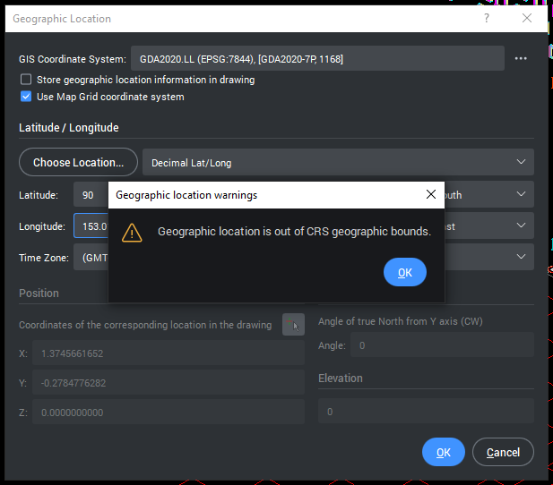
Hi Lyubov,
I am not sure of what I am doing hence my silly question.
I did find the one you mentioned in the GIS Coordinate System dropdown. But I am not able to progress due to lack of knowledge. I keep getting this message.
Here are the details of what I have to set for my model
Geodetic Datum used : GDA2020
Height Refernce : Australian Height Datum (AHD): RL34.904
Grid Datum : Australian Geodetic Datum (AGD): PM52464
Project Base Point :
N/S: 6951503191.0
E/W: 504671485.4
Elev: -340.0
Rotation: 9.38 deg
Other information that you might need is
Project is located in Toowoomba, Queensland, Australia
Closest city location as per GIS is Brisbane, Australia
Timezone is Brisbane, Australia
Could you please try these values and educate me on how do I apply these to the dialog box above.
Hope this is enough information for you to help me
Regards,
0 -
I've been out of action for a while and now my trial has expired.
Loath to upgrade unless this works as its really the only reason I need, want, to upgrade for. Be nice to know if this is fixed.
0