Exporting a world file for an image inserted in a drawing.

BCSTools by DotSoft has the ability to create a world file for an image inserted in a drawing.
Is there any equivalent feature in BricsCAD Pro to write a world file for an image insert?
As a side note you should set the full path not a relative path to the image inserted. A relative path causes BCSTools to attempt to write the world file in the program folder not the image folder. Then the program fails because of write permissions being restricted.
Comments
-
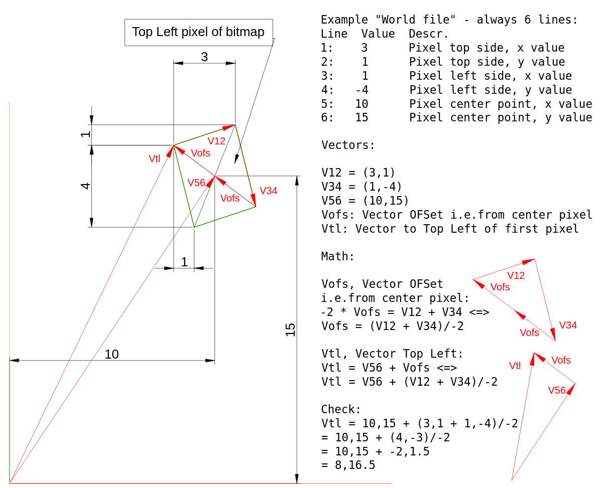
What's a world file?
0 -
CADontheBrain, that's relatively easy to solve. Can DotSoft arrange that for you?
Recently, I had to come up with a solution for placing geo-images because AutoCAD can't do it and BricsCAD didn't place the image properly (bug, hope it's fixed). Here's a machine translation:
https://vanderworp-org.translate.goog/gis-afbeeldingen-invoegen-in-bricscad-en-autocad/?_x_tr_sl=auto&_x_tr_tl=en&_x_tr_hl=nl
Basically, you want the same thing, but the other way around. I'm sure there are Lisp programmers on this forum who would be willing to help you with this for a reasonable fee.
0 -
Tom, it is metadata of an image, containing geometrics for placing.
0 -
Oh yeah, I've been playing with that recently.
Downloading LIDAR-based terrain data (1m grid, vertical accuracy 15cm), free from UK Environment Agency, I've learned to process it through QGIS and CloudCompare to import into Bricscad to create two superimposed TINs - one the bare ground, one same including the trees and buildings, which can them be imported to Twinmotion along with the building model.
The problem has been to preserve the geolocation data through these stages, so it arrives in Bricscad properly scaled and oriented to agree with the building model, also geolocated. Failed - not sure at what stage - I suspect it's Bricscad's fault.
0 -
dotsoft is now served by Carlson. Not sure what service you get from them? Terry was very good, hopefully that side continues. Terry passed away late last year.
This January, Carlson Software announced the purchase of DotSoft, LLC, after the passing of Terry Dotson in December, 2024. Terry had worked for Carlson for over a decade before returning to private business, and recognizing Terry's contributions to the CAD marketplace, Carlson Software is carrying forward Terry's work and continuing support and development of DotSoft's products.
The world file is a simple text file with right extension. .tfw for example.
if you know the parameters you could concoct one. I think they're about 4 lines. Coordinates, scale??
Some images have them embedded in the image. Is that what Dotsoft did?
0 -
Rather than write my version of an explainer this wiki says it better.
0 -
I found this LISP routine in my treasure trove of utilities. It creates a world file for a Windows Meta File (.wmf). Please adapt for use with other image file extensions if you are feeling generous. Thanks
0 -
As suggested we got JGW files as well as a JPG file from our GIS, we could load as many images as we liked then just select them and run this lisp. It would scale and place correctly.
A JGW file is a text file with image information.
4.2281642006357
0.0000000000
0.0000000000
-4.2281642006357
475375.000002981
6923150.00000308The big numbers are the real world co-ordinates if I remember correct it is one of the corners., the 4.228 I think is a scale factor. The 0,0 is insert point.
Rename TXT to JGW
1 -
Hmm, I sharpened a pencil and wrote this very quick and dirty. The link I posted earlier explains. This is what is happening:
Not tested(!), here is some code, drag it in your drawing and run command:
MakeWorldFileHave fun!
1 -
Thanks for the detailed discussion. I submitted a feature request with BricsCAD Support to add a command that will create a world file.
0


